Find the Right Flight Package & GSD for Your Project
Accuracy and efficiency are a balance — explore examples and recommendations below
Flight Package: Cost vs. Capability
Your choice of flight package determines both cost and deliverable options. Our Essential flight is fast and efficient for basic mapping, while our Standard multiflight package enables advanced deliverables like contours and 3D models.
Essential (1-Flight)
- Baseline cost (1x)
- Lowest processing time, fastest delivery
- Best for large AOIs, orthomosaics only
Standard (3-Flights)
- 2 -3 x cost
- Rich detail, strong edge quality
- Best for 3D models, slope maps, construction sites
(Scroll down for sample images for Flight Package and GSD seleciton)
Which Flight Package Fits Your Project Best?
🚁 Essential Single Flight Package
Fast, cost-efficient capture for flat, open sites.
- Straight-down imagery only
- Best where horizontal measurements matter most
- Simplest field workflow and shortest turnaround
- RTK-enabled positional accuracy (same as 3-flight)
📐 Standard 3-Flight Package
Multi-angle capture that improves edges and verticals.
- Essential Flight plus two angled passes
- Higher fidelity on buildings, walls, slopes, utilities
- Sharper seamlines and cleaner feature outlines
- RTK-enabled positional accuracy (same as single nadir)
| Feature | Essential | Standard |
|---|---|---|
| Best For | Flat, simpler sites | Sites with vertical features or complex terrain |
| Output Look | Clean top-down orthomosaic | Sharper edges and clearer structure outlines |
| Upright Structures (Fidelity) | Edges near walls/roofs can skew or stretch | Straighter walls and improved roof/wall transitions |
| Accuracy | RTK-enabled positional accuracy | RTK-enabled positional accuracy |
| Turnaround & Cost | Lower | Higher |
| Resolution Note* | Same GSD as 3-flight | Same GSD; multi-angle views yield higher perceived detail |
Why Package Choice Impacts Accuracy & Detail
Essential uses only straight-down photos. Tall features can “lean,” and edges near walls and rooflines may look stretched.
Standard adds angled views so the software sees walls and edges from multiple sides. The result is higher-fidelity vertical features, cleaner seamlines, and clearer definition around slopes and site edges.
*When flown at the same altitude, both packages share the same pixel size (GSD). The Standard flight package often appears up to 2× sharper because multi-angle imagery improves edge clarity and orthorectification around verticals.
Flight Package vs. Capability
| Project Type | Flight Package | Recommended GSD | Notes / Deliverables |
|---|---|---|---|
| Golf greens / fine features | Standard | 1.0–1.5 cm/px | High-accuracy surfaces, slope analysis, bunker volumes |
| Subdivision progress | Standard | 2.0 cm/px | Edge detail, 3D modeling for site planning |
| Floodplain mapping | Standard | 2.5–3.25 cm/px | Cost-efficient coverage, ortho + contours |
| 3D cut/fill models | Standard | 1.0–2.0 cm/px | Stockpile volumes, earthwork, terrain changes |
| Landfill cap / large earthwork | Standard | 2.0–2.5 cm/px | DEM, slope, compliance reports |
| Golf course (whole site) | Standard | 2.0–2.5 cm/px | Balance between detail & coverage |
| Municipal drainage corridor | Standard | 1.5–2.0 cm/px | Contours, slope heatmap, hydrologic modeling |
| Agricultural field mapping | Essential | 2.5–3.25 cm/px | Fast coverage, crop health ortho only |
| Building façade / vertical detail | Standard | 1.0–1.5 cm/px | Requires obliques for vertical capture |
| Stockpile inventory (simple) | Essential | 2.0–2.5 cm/px | Quick volumetrics possible with nadir-only |
| Stockpile inventory (complex) | Standard | 1.5–2.0 cm/px | Better geometry, accuracy, and surface modeling |
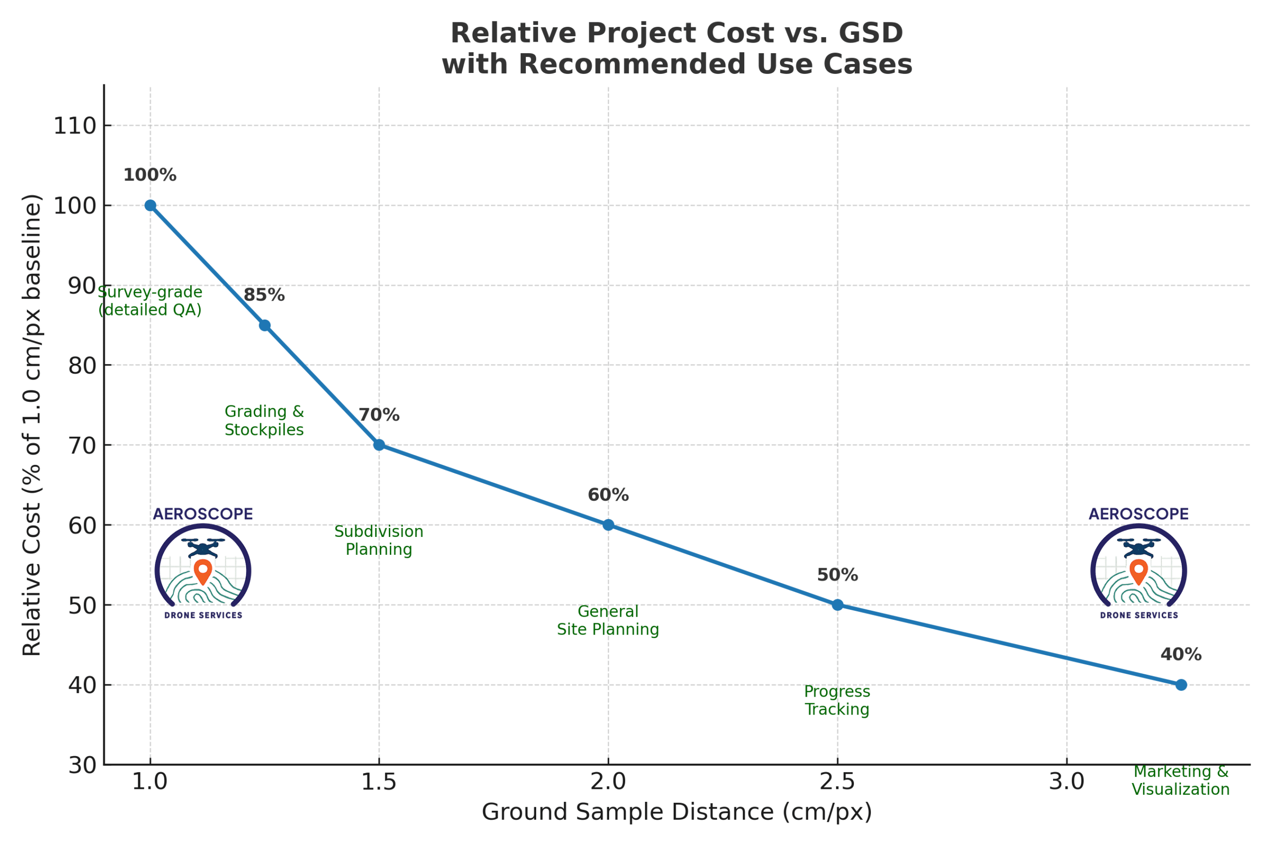
How Resolution (GSD) Affects Cost & Clarity
Lower GSD captures finer detail at higher cost. Explore the impact of GSD for both Essential (single flight) capture of flat surfaces (football field markings) and Standard (multi-flight) dealing with vertical detail (soccer goals, benches) at multiple resolutions.
These demos combine results from separate, precisely repeated flights along identical routes and altitudes to permit you to directly compare the effect of GSD. Because the sun moves between passes, you may notice shifts in shadows—but the ground features remain perfectly aligned. Those subtle shadow changes highlight our flight path repeatability and the precision of RTK positioning.
The demos use a limited zoom range and simplified tools for fast loading. Want full-resolution tiles and the full feature set? Open the full sample viewer. (link beneath each demo viewer)
Flight Package: Essential (1-Flight, for flat fields/areas)
This demo combines results from separate, precisely repeated flights along identical routes and altitudes to permit you to directly compare the effect of GSD. Because the sun moves between passes, you may notice shifts in shadows—but the ground features remain perfectly aligned. Those subtle shadow changes highlight our flight path repeatability and the precision of RTK positioning.
This demo uses a limited zoom range and simplified tools for fast loading. Want full-resolution tiles and the full feature set? Open the full sample viewer.
Flight Package: Standard (Multi-Flight, for buildings/structures)
The Standard Multi-Flight package delivers a sharper result at the same GSD compared to the Essential Single-Flight package. In the single-flight output, the tattered fabric on the top of the goal post appears blurred, while in the multi-flight output the torn edges are clearly defined. Similarly, the upright post to the right of the goal is captured as a straight, well-formed object only in the multi-flight dataset. These examples show why additional captures and finer GSD matter: at coarser resolutions railings blur and geometry degrades, but at finer GSD details remain measurable and 3D models more accurate..
As resolution increases, capture costs rise, but so does the accuracy and range of uses.
Higher-resolution GSD (< 1.0, recommended only for small AOI) available on request — contact us for details